|
|
|
|
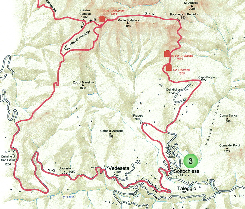
Sottochiesa (m. 758) - Vedeseta (m. 805) - Culmine San Pietro (m. 1260) - Piani di Artavaggio
Refuge Cazzaniga (m. 1889) - Refuge Gherardi (m. 1600) - Capo Foppa (m. 1280) Fraggio (m. 992) - Sottochiesa (m. 758).
|
|
|
IGM 1:50.000 n° 076 Lecco Kompass 1:50.000 n°105 Lecco / Valle Brembana
|
|
|
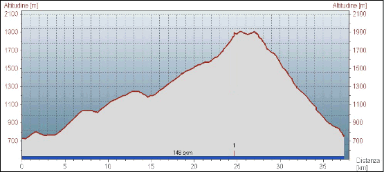
Km 38 ca.
|
|
|
1200 m.
|
|
|
4,00 h
|
|
|
MC + / OC
|
|
|
June October
|
|
|
Asphalt Road Dirt Road Path Mule-track
|
|
|
100 % (for some short stretch of path you'll have to push)
|
|
|
At the beginning and at the ending make sure of snow presence
|
Park your car at the village square Sottochiesa (mt. 758) and begin your cycle on a 10 km asphalt road, to the mountain narrow called Culmine di S. Pietro (mt.1.260), cycling across the villages of Olda (mt. 766), Vedeseta (mt. 820) and Avolasio (mt.1.050).
This asphalt road is not really frequented and so you can cycle quite freely, enjoing the view of the mountain of Resegone (mt. 1.875) and having the possibility to meet the fauna of the Orobie Alps. Once at the Culmine di S. Pietro (the narrow between the Taleggio Valley and Valsassina ), you have to follow the road down for almost a km until a dirt road with a gate: here is where the ascend slop starts.
This road starts well cycling with a slope across a wood and with some hairpins bends (you can see from far away the Nicola Refuge's pyramid). During this stage you can find different springs where is possible to drink. From Piani di Artavaggio the ascend slope become less winding and it's possible to cycle easier, before the last climb to get the Cazzaniga Refuge (mt.1.889). This last climb is pretty hard with gravelly soil (be carefull at the downhill).
If you make this route on Spring you can find a unique view with the flora (especially gentians) and so many marmots. Shortly afterwards, beyond the Nicola Refuge, you find tha Cazzaniga Refuge (mt.1.889) where you can have a perfect alpine lunch. From here begins the best part of this route, taking the poath that leads to the Sodadura Mountain (mt. 2.010). After some ascents and funny downill drops you reach the Sodadura Narrow (mt.1.867). Go beyond a drinking trough and you'll find a little chalet from where a path (almost for trial) takes you across some ballastes to the Gherardi refuge. At the Gherardi Refuge starts the path that goes down to Capo Foppa (follow the targets red-white) and to the village of Fraggio.
Copyright © 2006 - www.mtbinvalbrembana.it - by Claudio Locatelli